New seismic imaging technique gives fresh look at Earth’s mantle
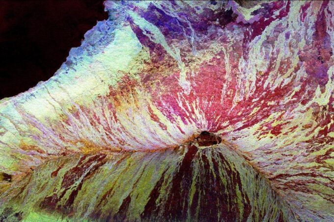
This image of the Mauna Loa volcano on the Big Island of Hawaii shows the capability of imaging radar to map lava flows and other volcanic structures. Image credit: NASA/JPL
One thousand kilometers below the Pacific Ocean seafloor southeast of Hawaii, deep in the Earth’s mantle, lurks a phenomenon that has left scientists puzzled: an expanse of hotter-than-average solid rock that runs along the Hawaii-Emperor Seamount chain and ends near Mauna Loa, Hawaii. Although seismologists have observed anomalous structures like this one, known as mid-mantle discontinuities, for decades in different locations, even the most sophisticated seismic imaging methods have struggled to map them in detail and resolve the abrupt changes in their boundaries.
Now, a paper published in Nature Communications led by Zhendong Zhang, a postdoctoral fellow in the Department of Earth, Atmospheric and Planetary Sciences (EAPS) details a new seismic imaging method that tells us more about the physical properties of the mantle below the Pacific and helps propose possible explanations for these enigmatic mind-mantle discontinuities.
“Using our imaging method, we show a very clear structure of the mid-mantle discontinuity below Hawaii and we explain the possible reason for it,” Zhang says.
The method, called Reverse Time Migration Full Waveform Inversion (RTM-FWI), is able to resolve sharp variations in the mass density and seismic wave speeds of the mantle, marked “impedance” contrasts that other methods have struggled to bring into focus. By combining RTM-FWI with published tomographic models of mantle wave speeds, which faithfully capture the smooth background variations in medium properties, co-author and Professor of Geosciences at Princeton, Frederik Simons PhD ’02, says they were able to “marry ‘the sharp and the smooth’, so to speak, and reap the benefits of both types of methods”.
In addition to Zhang and Simons, the paper was authored by Jessica Irving from the University of Bristol and Tariq Alkhalifah from the King Abdullah University of Science and Technology.
Using seismic data collected in the area from 2010 to 2019, Zhang and his team looked at the behavior of seismic waves as they travel through the Earth. When seismic wave motion changes, either through bending, reflecting, or refracting, it reveals variations in the medium that they traveled through.
With the help of a supercomputer, the team ‘spared no physics’, says Simons, by solving the full wave equation in the whole mantle domain, both forward (from every earthquake to every seismometer) and backward (starting from the receiver signal and working back to the source). After calculating the interactions between these thousands of pairs of wavefields, the team was able to see how changes in the properties of the solid mantle rock contrasted with the background model. Zhang said they could see the wave speeds slowing around the mid-mantle discontinuity, indicating that the material below it was hotter than its surroundings. The team theorized that the branching, tree-like structure of the mantle plume feeding this Hawaiian “hot spot” may be partially responsible for the anomalous structure that their model picked up on.
Mid-mantle discontinuities observed in other areas of the world often appear to be the result of cold material descending into the mantle in subduction zones; but this is not the case for Hawaii, where there is upwelling, rather than subduction, of mantle material. Because of this, “there is no clear explanation for this mid-mantle discontinuity,” says Zhang.
While the team has ideas involving a hot mantle plume, more work needs to be done before they can say for sure what is causing the feature 1000 km below the Pacific. “Our results point the way forward but don’t completely resolve all of the issues,” says paper author Jessica Irving. “Understanding what we are seeing, and how Earth’s dynamics have caused it, will undoubtedly become a multidisciplinary effort.”
Zhang hopes that this research will help bridge the gap between more traditional seismic imaging methods that are good at painting uniformly smooth, approximate pictures of the Earth’s interior, and newer methods that can robustly resolve changes and image prominent discontinuities in the Earth. Next, he’s planning to collect more data globally so that he can use RTM-FWI to cover more area for imaging the mantle below the Pacific Ocean and search for evidence as to why the Hawaii-Emperor seamount chain changes direction so abruptly.
“We will try to answer this question in the near future,” he says.